哈爾濱哈光經緯森林羅盤儀帶三腳架地質煤礦測量儀器
哈爾濱哈光經緯森林羅盤儀帶三腳架地質煤礦測量儀器介紹
中文介紹
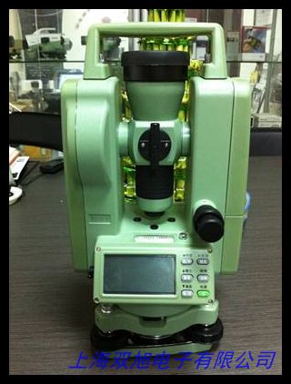
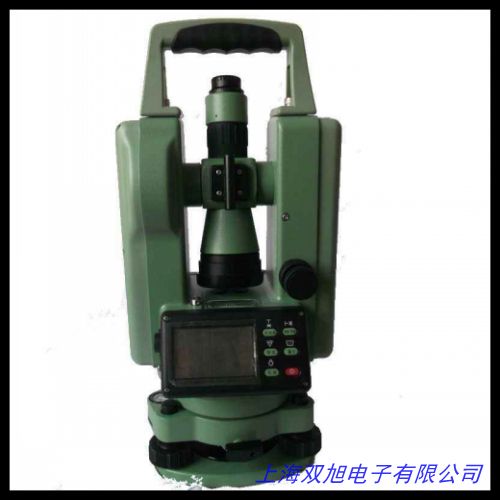
哈爾濱哈光經緯森林羅盤儀帶三腳架地質煤礦測量儀器是一款專業的測量工具,適用于地質勘探、煤礦測量以及森林資源調查等多種領域,為相關工作提供了精準可靠的數據支持。
該儀器采用先進的光學系統,能夠清晰地顯示測量目標,確保測量結果的準確性。其羅盤儀部分,通過精確的磁性感應技術,可以快速準確地測量出方位角,幫助測量人員確定目標的方向。經緯儀功能則能夠精確測量水平角和垂直角,為地形測繪、工程測量等提供關鍵數據。配備的三腳架設計穩固,能夠在各種復雜地形條件下保持儀器的穩定,無論是崎嶇的山地還是煤礦井下的特殊環境,都能確保測量工作的順利進行。
儀器的外殼采用高強度材料制成,具有良好的抗沖擊性和耐腐蝕性,能夠適應各種惡劣的工作環境,長時間使用仍能保持良好的性能。操作界面簡潔直觀,方便測量人員快速上手,提高工作效率。此外,儀器還具備一定的防水防塵性能,進一步增強了其在戶外環境中的耐用性。
哈爾濱哈光經緯森林羅盤儀帶三腳架地質煤礦測量儀器憑借其出色的性能和可靠的品質,成為了地質、煤礦以及林業等領域測量工作的得力助手,助力專業人員完成各種高精度的測量任務,為相關行業的發展提供了有力的技術支持。
English Introduction
The Harbin Haguang Theodolite Forest Compass with Tripod Geological Coal Mine Surveying Instrument is a professional measuring tool designed for a variety of applications, including geological exploration, coal mine surveying, and forest resource investigation. It provides accurate and reliable data support for relevant work.
The instrument features an advanced optical system that offers clear visibility of the measurement target, ensuring the accuracy of the results. The compass part utilizes precise magnetic induction technology to quickly and accurately measure azimuth angles, helping surveyors determine the direction of the target. The theodolite function can precisely measure horizontal and vertical angles, providing key data for topographic mapping and engineering surveys. The included tripod is designed for stability, allowing the instrument to remain steady in various complex terrains. Whether in rugged mountains or the unique environment of coal mine shafts, it ensures the smooth progress of measurement work.
The instrument s housing is made of high - strength materials, offering excellent impact resistance and corrosion resistance. It can withstand harsh working environments and maintain good performance over long - term use. The user - friendly interface is intuitive and easy to operate, enabling surveyors to quickly get started and improve work efficiency. Additionally, the instrument has certain water - and dust - proof capabilities, further enhancing its durability in outdoor conditions.
The Harbin Haguang Theodolite Forest Compass with Tripod Geological Coal Mine Surveying Instrument, with its outstanding performance and reliable quality, has become an indispensable tool for measurement work in the fields of geology, coal mining, and forestry. It helps professionals complete various high - precision measurement tasks and provides strong technical support for the development of these industries.
哈爾濱哈光經緯森林羅盤儀帶三腳架地質煤礦測量儀器
沈陽艾隆條式水平儀150 200 300鉗工水平儀框式水平儀現貨,成都代理華測彩途N100/NAVA100手持GPS測畝儀 測坐標 經緯度 面積,香港的舊經緯儀如何進口清關到國內,大疆無人機 大疆無人機官網 無人機報價 大疆航拍無人機,創元蘇州一光蘇一光蘇光經緯儀DT22L/DT22RL電子激光經緯儀對點。袖珍經緯儀 DQL-2A 利用磁針通過刻度盤讀數來確定目標方位,YB511B型織物密度鏡 ,水準儀腳架鋁合金木質水準儀三腳架 經緯儀全站儀水平儀三腳架,科技A10北斗導航戶外手持GPS經緯度定位儀船用坐標測畝儀器,Metone 597 溫濕壓一體化傳感器。夏季處理中 帶485接口的控制器 經緯儀控制器,專業生產各種規格的高品質水泡水平儀,6回路經緯時控儀CH09-A經緯儀, 高性能電子激光工程測繪經緯儀 全站儀 水準儀 水平儀。深達威電工管道探測器 墻體探測儀電線管排堵器PVC管探管器測堵,經緯密度鏡/緯密鏡/密度尺/織物密度鏡 一套5片,日本二手經緯儀進口清關代理, 水平儀 氣泡水平儀 支架水平泡 水準泡 水平器 水平泡, 激光電子經緯儀 DJD2-JCL 博飛品牌 。
上一篇 四川成都實體店北京三鼎電子經緯儀DT02CL/DT02L激光下對點 http://www.uoncy.cn/product/d122710.html
|


