激光經(jīng)緯羅盤儀
產(chǎn)品概述
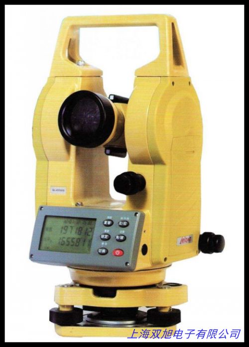
激光經(jīng)緯羅盤儀是一種集光學(xué)測量、磁方位角測定與激光指向功能于一體的多功能工程測量儀器。該儀器采用高精度光學(xué)系統(tǒng)與半導(dǎo)體激光技術(shù),適用于礦山開采、森林資源調(diào)查、農(nóng)田水利規(guī)劃、地形測繪等場景,可高效完成方位角、水平角、垂直角、高差及距離等測量任務(wù)。其設(shè)計兼顧便攜性與穩(wěn)定性,操作簡便,數(shù)據(jù)可靠。1713
技術(shù)特點(diǎn)
儀器配備16倍正像望遠(yuǎn)鏡,有效口徑22mm,視場角2°30′,最短視距2.5m,支持視距乘常數(shù)100的快速測距。水平度盤與豎直度盤格值均為1°,游標(biāo)精度達(dá)5′,磁羅盤磁針長度67mm,可精確測定磁方位角。內(nèi)置635nm波長激光器,功率5mW,射程50m,激光束與望遠(yuǎn)鏡光軸平行,便于目標(biāo)瞄準(zhǔn)與施工指向。水準(zhǔn)器角值30′/2mm,確保測量穩(wěn)定性。儀器采用輕量化設(shè)計(重量約0.82kg),適應(yīng)0-40℃工作環(huán)境。41122
應(yīng)用場景
激光經(jīng)緯羅盤儀廣泛應(yīng)用于煤礦井下巷道標(biāo)定、森林資源普查、土地規(guī)劃及水利工程測量。其激光指向功能可輔助隧道掘進(jìn)、大型設(shè)備安裝等高精度定向作業(yè),同時兼容傳統(tǒng)羅盤儀的方位測量需求。儀器還可用于樹木高度測定、坡度分析等野外調(diào)查任務(wù),滿足多行業(yè)工程測量需求。72025
操作與維護(hù)
儀器通過三腳架快速安平,磁針止動螺旋與微調(diào)機(jī)構(gòu)便于精準(zhǔn)讀數(shù)。激光開關(guān)一鍵控制,支持10米外標(biāo)靶校準(zhǔn)光軸。日常使用需避免劇烈震動,存放時需取出電池并保持干燥環(huán)境,光學(xué)部件需防塵防霉。1325
English Version
Product Overview
The Laser Theodolite Compass is a multifunctional surveying instrument integrating optical measurement, magnetic azimuth determination, and laser pointing. Featuring high-precision optics and semiconductor laser technology, it is suitable for mining, forest resource surveys, agricultural water conservancy planning, and topographic mapping. It efficiently measures azimuth, horizontal/vertical angles, height differences, and distances, with a compact and stable design for field operations.17
Technical Features
Equipped with a 16x erect-image telescope (22mm aperture, 2°30′ field of view), the instrument supports a 100x stadia ratio for rapid distance measurement. Horizontal and vertical scales offer 1° graduations with 5′ vernier accuracy. The magnetic compass (67mm needle) ensures precise azimuth readings. A 635nm laser (5mW, 50m range) aligns with the optical axis for targeting. The 30′/2mm leveling bubble enhances stability, while the lightweight (0.82kg) body operates in 0-40℃ environments.411
Applications
Ideal for tunnel alignment, forest inventories, and land surveys, the instrument assists in directional tasks like equipment installation and slope analysis. Its dual functionality (laser pointing + traditional compass) adapts to diverse fieldwork, including tree height measurement and engineering layout.2025
Operation & Maintenance
Quick-leveling via tripod, the device features magnetic needle locks and fine-adjustment knobs for accuracy. The laser can be calibrated using a 10m target. Avoid shocks, store without batteries, and protect optical components from moisture.1325
激光經(jīng)緯羅盤儀
DT-02LL經(jīng)緯儀 中文電子經(jīng)緯儀 激光電子經(jīng)緯儀,高品質(zhì)8x35mm圓柱水平泡 水平儀水準(zhǔn)泡 水平珠,標(biāo)智手持式溫濕度計 工業(yè)高精度數(shù)顯濕度計溫濕表 數(shù)字濕度計,圓形水平泡,小圓水平儀,圓水準(zhǔn)器,GARMIN佳明eTrex10戶外手持GPS經(jīng)緯度海拔定位儀導(dǎo)航儀測畝器。高檔方形水準(zhǔn)泡水平泡水平儀水平器 ,駿河精機(jī)SURUGA SEIKI激光自動準(zhǔn)直儀,彩途K20b戶外手持GPS定位測量經(jīng)緯度導(dǎo)航海拔定位gps測畝儀,經(jīng)緯時控/經(jīng)緯時控器/經(jīng)緯時控儀-路燈照明專用 優(yōu)惠,升降腳架,經(jīng)緯儀腳架生產(chǎn)圖紙制造技術(shù)專題技術(shù)大全。徠卡新品TS02全站儀TS06TS09 PLUS超拓普康索佳尼康2M天寶賓得,彩途F62手持GPS導(dǎo)航經(jīng)緯度戶外衛(wèi)星定位儀北斗高精度定位器測繪,四川成都 三鼎經(jīng)緯儀DT-02L 普通激光電經(jīng) 激光指向激光對中,密度鏡Y511C型折疊式照布鏡。經(jīng)緯度控制+時間控制+光照度控制 /ET301 艾貝斯1/2路智能控制器,高品質(zhì)水準(zhǔn)器促銷,激光電子經(jīng)緯儀銷售維修常州大地DE2A-L,常州大地電子經(jīng)緯儀DE2AL 上下激光對點(diǎn)經(jīng)緯儀,導(dǎo)熱系數(shù)測定儀 平板導(dǎo)熱系數(shù)測試儀 導(dǎo)熱系數(shù)測試儀 導(dǎo)熱儀。
上一篇 四川成都大地電子經(jīng)緯儀DE2A/DE2K 大地經(jīng)緯儀激光下對中穩(wěn)定 http://www.uoncy.cn/product/d122655.html
|


