Garmin佳明eTrex201x戶外手持GPS經(jīng)緯度定位坐標(biāo)導(dǎo)航儀器
產(chǎn)品概述
Garmin佳明eTrex201x是一款專(zhuān)為戶外探險(xiǎn)設(shè)計(jì)的專(zhuān)業(yè)級(jí)手持GPS導(dǎo)航設(shè)備,采用雙星定位系統(tǒng)(GPS+GLONASS),提供快速精準(zhǔn)的定位能力。其防眩彩色屏幕在強(qiáng)光環(huán)境下依然清晰可見(jiàn),配合符合人體工學(xué)的單手操控設(shè)計(jì),適合野外測(cè)量、地質(zhì)勘察、農(nóng)業(yè)測(cè)繪等多種場(chǎng)景使用。設(shè)備內(nèi)置8GB存儲(chǔ)空間并支持?jǐn)U展,可記錄2000個(gè)航點(diǎn)和10000條航跡,滿足長(zhǎng)時(shí)間戶外作業(yè)需求。1922
核心功能特點(diǎn)
該設(shè)備具備專(zhuān)業(yè)面積測(cè)量功能,支持航跡、航線及等寬測(cè)量模式,測(cè)量過(guò)程中可暫停并保留數(shù)據(jù),關(guān)機(jī)后仍能接續(xù)計(jì)算。獨(dú)特的坐標(biāo)系統(tǒng)轉(zhuǎn)換功能兼容北京54、西安80和CGCS2000等多種坐標(biāo)系,方便不同領(lǐng)域用戶使用。內(nèi)置40多項(xiàng)行程信息顯示功能,可實(shí)時(shí)查看定位導(dǎo)航與測(cè)量數(shù)據(jù),集成電子羅盤(pán)、日月天文等實(shí)用工具。IPX7級(jí)防水防震設(shè)計(jì)確保在惡劣環(huán)境中穩(wěn)定工作,兩節(jié)AA電池可提供長(zhǎng)達(dá)22小時(shí)的續(xù)航。2815
技術(shù)參數(shù)與設(shè)計(jì)
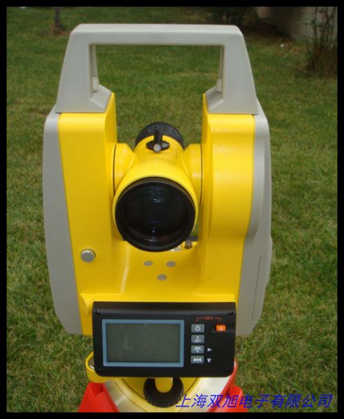
eTrex201x采用5.4×10.3×3.3cm緊湊機(jī)身設(shè)計(jì),重量?jī)H141.7克(含電池),配備2.4英寸半透式彩色TFT顯示屏(分辨率176×220)。雙星接收芯片顯著提升在復(fù)雜地形中的定位速度與精度,典型定位精度可達(dá)3米。通過(guò)USB接口可連接電腦傳輸數(shù)據(jù),支持導(dǎo)入等高線地圖、DEM高程圖及自制地圖,滿足個(gè)性化導(dǎo)航需求。三防結(jié)構(gòu)通過(guò)防摔、防水(1米水深30分鐘)和防炫目測(cè)試,適應(yīng)極端戶外條件。101826
應(yīng)用場(chǎng)景與優(yōu)勢(shì)
This handheld GPS navigator is ideal for outdoor enthusiasts and professionals engaged in hiking, surveying, and field research. Its sunlight-readable display and rugged construction withstand harsh environments while providing reliable positioning. The intuitive five-way joystick allows easy operation with one hand, even when wearing gloves. With energy-efficient technology, it achieves exceptional battery life for extended expeditions. The device s area calculation feature proves valuable for land measurement tasks, offering three distinct measurement methods with resume capability. Multi-language support including Chinese and English interfaces enhances global usability.[4713
系統(tǒng)與擴(kuò)展性
The eTrex201x supports flexible memory expansion via microSD cards, allowing virtually unlimited storage of waypoints and tracks. Users can customize data fields to display preferred navigation metrics and utilize the photo navigation function with geotagged images. The built-in trip computer records distance, speed, and elevation profiles, while the trackback feature guides return along recorded paths. Compatible with Garmin BaseCamp software for advanced route planning and data management on PC platforms. These features combine to create a versatile tool for diverse outdoor positioning requirements. 51723
Garmin佳明eTrex201x戶外手持GPS經(jīng)緯度定位坐標(biāo)導(dǎo)航儀器
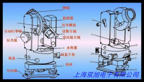
總輻射傳感器BL-ZFS,各種優(yōu)質(zhì)玻璃長(zhǎng)水準(zhǔn)泡 水平儀質(zhì)優(yōu)價(jià)廉,保證 蘇一光電子經(jīng)緯儀帶上下激光電子經(jīng)緯儀/全站儀,DT-02LL經(jīng)緯儀 中文電子經(jīng)緯儀 激光電子經(jīng)緯儀,蘇光電子經(jīng)緯儀LT202L蘇州一光激光電子經(jīng)緯儀 雙激光。彩途導(dǎo)航儀K82B 面積經(jīng)緯度坐標(biāo)海拔 雙星測(cè)繪GIS數(shù)據(jù)采集北斗,南京日華J6E正像光學(xué)經(jīng)緯儀無(wú)錫經(jīng)銷(xiāo)經(jīng)緯儀無(wú)錫維修,ALUSYS鋁熔爐熱通量采集系統(tǒng),經(jīng)緯密度鏡/緯密鏡/織物密度鏡/SFY2 41型公制,日本制OK大菱電子水準(zhǔn)器 AC30。金屬圓水平儀 高精度水準(zhǔn)器 牛眼水準(zhǔn)儀 帶安裝孔水準(zhǔn)泡,蘇一光 光學(xué)經(jīng)緯儀配件 J2 J6儀器上各種配件 可整體出售,科利達(dá)DT-02/05系列電子經(jīng)緯儀NB-10A電池,海云北京博飛經(jīng)緯儀 EDJS-JCL 上下激光。集思寶G138BD戶外手持gps測(cè)畝儀北斗定位儀經(jīng)緯度測(cè)繪G,SRA01反照率輻射傳感器Hukseflux,科力達(dá)老式經(jīng)緯儀電池KB-10A電子激光經(jīng)緯儀電池科力達(dá)DC-02L電池,高品質(zhì)8x35mm圓柱水平泡 水平儀水準(zhǔn)泡 水平珠,激光經(jīng)緯羅盤(pán)儀 。
上一篇 工程電子經(jīng)緯儀,電子經(jīng)緯儀技術(shù)原理結(jié)構(gòu)圖紙專(zhuān)題貨到付款 http://www.uoncy.cn/product/d122487.html
|


