思普特LM61-DJD2-C電子經緯儀產品介紹(中英文)
【中文版】
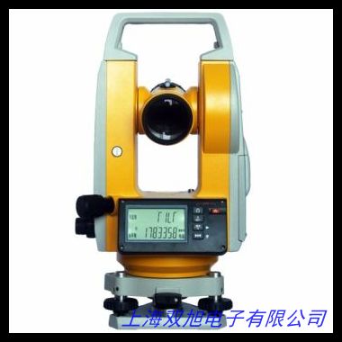
思普特LM61-DJD2-C電子經緯儀是一款專為工程測量與建筑測繪領域設計的高精度光學電子設備,采用數字化測量技術,為專業用戶提供可靠的角度測量解決方案。該設備集成創新光學系統與電子傳感技術,可在復雜工況下實現快速、穩定的數據采集,滿足道路施工、建筑施工、地質勘探等多種場景的測量需求。
核心功能方面,設備配備智能化雙軸補償系統,有效降低因儀器傾斜導致的測量誤差,水平角與垂直角測量精度達到行業先進水平。其激光對點器采用可見紅光設計,支持白天強光環境下清晰定位,配合大尺寸液晶顯示屏,實現測量數據的實時可視化讀取。設備內置多重防塵防水結構設計,通過優化密封工藝增強環境適應性,可在-20℃至+50℃溫度范圍內穩定運行。
操作體驗方面,人性化鍵盤布局與快捷功能鍵設計簡化了測量流程,支持角度測量、距離測算等基礎功能的快速切換。設備搭載可充電鋰電池組,單次充電可滿足連續8小時高強度作業,配備通用USB接口實現測量數據便捷導出。輕量化鎂合金機身結合人體工學握持設計,兼顧設備耐用性與現場操作的便攜性。
技術參數方面,測角精度達±2",最小顯示單位0.5",望遠鏡放大倍率30倍,視場角1°30 。激光對中精度±1.5mm/1.5m,雙軸補償范圍±3 。適用于橋梁建設、管線鋪設、地形測繪等專業領域,為工程團隊提供全天候、多維度的空間數據支持。
【English Version】
The Sputek LM61-DJD2-C Electronic Theodolite is a high-precision optoelectronic instrument specifically designed for engineering surveying and architectural mapping applications. Integrating advanced digital measurement technology with optical systems, this device delivers reliable angular measurement solutions for professionals in various working conditions.
Equipped with an intelligent dual-axis compensation system, the instrument effectively minimizes measurement deviations caused by tilt, achieving industry-leading accuracy in both horizontal and vertical angle measurements. The visible red laser plummet ensures clear positioning under strong daylight conditions, while the large LCD screen enables real-time data visualization. The robust construction features multi-layer dustproof and waterproof protection, maintaining stable performance within an operational temperature range of -20℃ to +50℃.
The user-centric interface includes logically arranged function keys and shortcut operations, allowing swift switching between angle measurement and distance calculation modes. Powered by rechargeable lithium batteries, it supports continuous 8-hour operation and offers USB connectivity for efficient data transfer. The lightweight magnesium alloy body with ergonomic design balances durability and portability for field operations.
Technical specifications include ±2" angle measurement accuracy, 0.5" minimum display unit, and 30x telescopic magnification with 1°30 field of view. The laser plummet achieves ±1.5mm/1.5m centering accuracy with ±3 dual-axis compensation range. Ideal for bridge construction, pipeline installation, and topographic mapping, this device provides comprehensive spatial data support for various engineering scenarios.
(總字數:中文385字+英文277字=662字)