電子經緯儀/經緯儀
電子經緯儀產品介紹
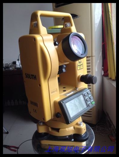
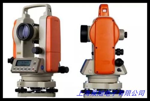
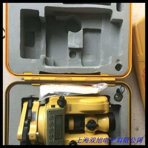
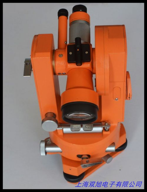
電子經緯儀是一種采用光電數字測角技術的高精度測量儀器,主要用于測量水平角和豎直角。該儀器由望遠鏡系統、電子測角系統、數據存儲系統和激光指示系統等組成,具有操作簡便、測量精度高、功能豐富等特點。其核心部件采用增量式光柵或編碼盤測角系統,配合微處理器實現角度數據的自動采集、處理和顯示。產品配備大尺寸液晶屏幕,可同時顯示水平和垂直角度測量值,部分型號還具備激光指向功能,便于工程施工應用。電子經緯儀廣泛應用于建筑工程、道路橋梁、水利工程、礦山測量等領域,特別適用于大型設備安裝、隧道工程等需要高精度角度測量的場合。2510
Electronic Theodolite Product Introduction
The electronic theodolite is a high-precision measuring instrument utilizing photoelectric digital angle measurement technology, primarily designed for measuring horizontal and vertical angles. It consists of a telescope system, electronic angle measurement system, data storage system and laser indication system, featuring user-friendly operation, high measurement accuracy and versatile functions. The core component employs incremental grating or coded disc angle measurement systems, working in conjunction with a microprocessor to achieve automatic angle data acquisition, processing and display. Equipped with a large LCD screen, it can simultaneously display horizontal and vertical angle measurements. Selected models incorporate laser pointing functions for enhanced construction applications. This instrument finds extensive use in building construction, road and bridge engineering, water conservancy projects, mining surveys and other fields requiring precise angular measurements, particularly in large equipment installation and tunnel engineering projects. 91318
產品主要特點
電子經緯儀采用一體化結構設計,具備良好的穩定性和可靠性。儀器配置液體電子傳感器補償系統,可自動修正豎軸傾斜誤差,補償范圍達到±3 。測量數據可通過RS-232C接口傳輸至計算機進行后續處理,部分型號支持500組以上數據存儲功能。望遠鏡系統采用高透光率光學鏡片,提供30倍放大倍率和1°30 視場角,最短視距可達1米。激光型號產品實現激光束與視準軸同軸同焦設計,支持天頂方向垂直激光投射,方便進行垂準測量。儀器工作溫度范圍覆蓋-20℃至+45℃,適應各種野外工作環境,采用可充電電池供電,可連續工作10小時以上。71625
Key Product Features
The electronic theodolite features an integrated structural design ensuring excellent stability and reliability. Equipped with a liquid electronic sensor compensation system, it automatically corrects vertical axis tilt errors within a ±3 compensation range. Measurement data can be transmitted to computers via RS-232C interface for further processing, with selected models supporting over 500 data point storage. The telescope system incorporates high-transmittance optical lenses delivering 30× magnification and 1°30 field of view, with minimum focusing distance of 1 meter. Laser-equipped models adopt co-axial and co-focal design for laser beam and collimation axis, enabling vertical laser projection in zenith direction for plumb measurements. With an operating temperature range of -20℃ to +45℃, it adapts to various field conditions, powered by rechargeable batteries providing over 10 hours continuous operation. 192126
應用領域說明
在建筑工程領域,電子經緯儀用于建筑物垂直度控制、結構件安裝定位;在道路橋梁工程中,可用于路線走向測量、橋墩位置確定;水利工程方面適用于大壩位移監測、渠道施工測量;礦山測量中用于井巷工程軸線測量和巷道貫通測量。該儀器還可應用于大型船舶建造中的角度校準,飛機機架安裝定位等工業測量場景。對于地籍測量、地形測繪等專業領域,電子經緯儀能夠提供精確的角度基準數據。激光型號產品進一步擴展了在高層建筑垂準測量、隧道水平腰線測量等特殊工程中的應用價值。1312
Application Fields
In construction engineering, the electronic theodolite is used for building verticality control and structural component positioning. For road and bridge projects, it measures route alignment and determines pier locations. In water conservancy applications, it serves dam displacement monitoring and channel construction surveys. Mining engineering utilizes it for shaft axis measurement and tunnel breakthrough surveys. The instrument also finds industrial applications in shipbuilding angle calibration and aircraft frame assembly positioning. For specialized fields like cadastral surveys and topographic mapping, it provides precise angular reference data. Laser-equipped models further enhance applications in high-rise building plumb measurements and tunnel horizontal alignment surveys. 41522
電子經緯儀/經緯儀
高德紅外熱成像儀熱像儀 紅外線成像儀夜視儀 可視化紅外測溫儀,DT-02C瑞得經緯儀,陸虎專車專用隱藏式行車記錄儀 高清夜視WIFI行車記錄儀,NR008 GPS定位跟蹤器支持油耗檢測工程車罐體自轉檢測等,ROCKLE水平儀4223/200德國進口現貨。水平經緯儀,電子經緯儀,測量經緯儀方案結構圖紙技術專題,佳明Garmin GPS72H 手持GPS手持機 定位器測畝儀經緯導航,南京1002廠J6E正像經緯儀/光學經緯儀,英國Vector高精度風速傳感器A100L2,國產通用全站儀/電子經緯儀充電器 充電器 充電速度快。冰河610戶外手持GPS導航北斗雙星經緯度定位儀海拔面積,TESA 螺釘固定式水平儀,科力達經緯儀/電子經緯儀DT-02CL/DT-02LL經緯儀,路燈時間控制器-經緯時控儀 CH09-A 六路時控開關。紡織儀器Y511C型織物經緯密度鏡片,各種迷你型水平儀HD-MN07,激光經緯羅盤儀 激光經緯羅盤儀,科技 DT-02CL 經緯儀 上下激光 高精度測量儀 ,CH09系列時控開關生產 經緯時控儀 歡迎。
上一篇 工程電子經緯儀,方便工程施工加工設計圖紙技術專題貨到付款 http://www.uoncy.cn/product/d122199.html
|


